That noise you hear is coming from my knees.


Sunday, December 21, 2014

Santa Clara Cinder Cone, November 27, 2014

Note: The reason why I’m posting these trail descriptions is because these are trails I’ve tried to research online and had difficulty getting much information from websites other than trails.com or another similar subscription website.  I don’t have a problem with commercial websites, but their information isn’t really much better anyway.

This is another site I remember from summer field geology in 1984.  It’s listed as “Cinder Cone” on the trail sign, and maps don’t really assign it a name, either.  To the north is a smaller, similar cone that is quarried for fine-grained highway cinders that bears the name Santa Clara Volcano.  The best description of the local geology can be found at UtahGeology.org (http://www.utahgeology.org/road_logs/uga-29_first_edition/SP_guide/snowcany.pdf) in the form of a road tour guide that includes nearby Snow Canyon State Park.


The trailhead is well-marked, with ample parking along the right side of the road at the top of a rise along Highway 18 near the northeast corner of Snow Canyon.  Whether or not the area is within the State Park, no fees are collected for parking and hiking.

There are two trails that ascend the cone.  The route nearest the parking lot is steep, loose and treacherous if you don’t have good shoes, and from what we observed, descending is not any easier.  The alternate (south) route winds around the east shoulder of the cone.  We took the south route for both ascending and descending, resulting in approximately two miles of hiking, including a full circuit of the crater rim.  Not that the alternate route is easy, but the footing is more secure.

Keep your eyes peeled as you walk along the trail.  A large number of cinder fragments are everywhere, and if you look long enough, you may find a few specimens of coveted “cow shit bombs”, prized by geologists and teenage boys.  Ejecta from the vent at just the right temperature becomes viscous enough to form these odd shapes on landing.  The basaltic lava from these volcanoes (dated variously from 10-27 thousand years old) contained a fairly high percentage of gas.  Try picking up a 12-15 inch specimen and the lack of weight may surprise you.  I don’t know if these pieces are light enough to float in water as some from Craters of the Moon are.


The summit provides excellent views of Snow Canyon to the west and the Pine Valley Mountains to the northeast.


A trail runs down into the crater from the north (lower) rim.  We didn’t bother; the vent is filled in with sediment.  But along the west rim, another small vent provided a bit of a surprise.  The vent is barely noticeable at less than 20 feet wide; most people probably walk past it without recognizing what it is.


If you look closely at the photo below, you might be able to see a small patch of lava that solidified in the vent at the end of what must have been a very short-lived side eruption.  Neat!


Taylor Creek Trail, November 25, 2014

The Taylor Creek trail is about a two-mile, easy hike up one of the finger canyons of the less-visited Kolob Terrace section of Zion National Park.  If you don’t have enough time to visit the main area of the park through Springdale, this is a quick excursion that shouldn’t take more than three hours at a leisurely pace.  The trailhead is on the left side of the road as you drive up from the entrance station.  If you have some extra time and don’t mind hiking off-piste, you can follow the creek bed on up to the end of the canyon where the walls narrow down.  For this trip, we turned around at the end of the marked trail.


The trail crosses forth and back over the creek numerous times…plan on splashing if the water is running high.  In late November, there was a nice layer of ice alongside the banks that made crossing easy and dry.


Like the rest of Zion, the high cliffs and towers of the Navajo Sandstone steal the geologic show (http://en.wikipedia.org/wiki/Geology_of_the_Zion_and_Kolob_canyons_area) on the Taylor Creek trail.


But a closer look might reveal a few things that aren’t as obvious, or as easily seen on other easy-access trails within the park.  The trail starts half-way up the regional stratigraphic column in the Kayenta Formation, a red layer of interbedded sand and siltstones.  The entire column is uplifted along the Sevier Fault that runs roughly north/south along the base of the cliffs of Hurricane Ridge.  Along the creek, deformation of the Kayenta sedimentary rock can easily be seen.


As you get further up the trail, keep an eye open for the grey limestone of the Carmel Formation (http://en.wikipedia.org/wiki/Carmel_Formation).  It will be in cobblestone to boulder-sized chunks that have fallen down from above the Navajo Sandstone cliffs.  It’s the remnants of a shallow seabed, and some layers are thick with fossil oysters and pectins, along with coral and crinoids (http://en.wikipedia.org/wiki/Crinoid).


There are two cabins built in the 1930’s that are in good condition and fun to explore.  One of the hikers we met on the trail had a level/plumb-bob app on his smart phone, and he was impressed that construction of Fife’s Cabin was so level and square.


The end of the official trail is at the Double Arch Alcove, where erosion of the cliff face has left a grotto along a layer where water seeps.  The second arch overhangs above.


When I took a five-week field course in geology during the summer of 1984, the Taylor Creek trail had not yet been constructed.  We mapped the canyon immediately to the north (which begins on private property), so I’ve been through this section before.  It’s nice that the Taylor Creek trail is now available, allowing easy access to this part of the park that most people only see from out the window as they do the “five-minute” auto tour of the Kolob section of Zion.


Monday, December 15, 2014

Searles Lake Gem-o-Rama, Oct. 17-18, 2014


The annual open weekend at Trona, California, hosted by the Searles Lake Gem & Mineral Society (http://www1.iwvisp.com/tronagemclub/GEM-O-RAMA.htm) and Searles Valley Mineral Company (SVMC, http://www.svminerals.com/default.aspx) was a fun family outing that I would encourage anyone with an interest in geology and mineralogy to attend.  Directions and descriptions of the various activities are well-documented on the Society’s website, so I won’t go into great detail here, other than to relate some of the experiences that might be helpful.


Camping

I can’t comment on local hotels because we brought an RV (travel trailer) and parked at the Valley Wells Recreation Area for two nights.  I filled the water tank on the RV before leaving home; this turned out to be a good thing.  While water is available, it’s located at the corner of the restroom building where many of the tent campers were set up.  It would have been awkward to pull into their campsites after dark to fill up the tank.  We also rented a fireplace, well worth the $5 per night.  I think I saw firewood available at one of the local gas stations, but we brought our own firewood, which made for a couple of very pleasant evenings.


There is plenty of level space for tents and RVs.  Campers with pets stay in a separate area outside the fenced portion of the property (Thank you!).  Be aware of some minimal glass and metal debris, along with sticker bushes.  (Everything that grows in the desert is trying to kill you, get used to it.)  For the most part, this is a clean, quiet, nice place to camp.  Restrooms are available.  If you leave a tent or canopy up during the day, make sure it’s wind-proofed and staked down, or it may get damaged or blown away.
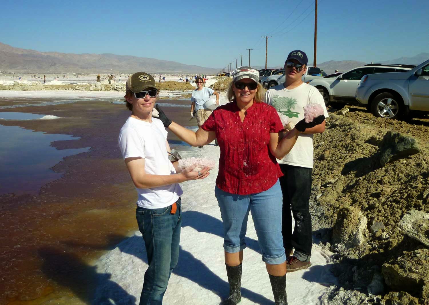
The Mud Trip

The SVMC brings out several truckloads of mud from below the surface of the lake bed, dumps it on the ground and several hundred rockhounds wallow in it, finding many colossally large crystals of hanksite, halite and borax.  Hanksite (http://en.wikipedia.org/wiki/Hanksite) is closely related to halite (salt), except that it also includes K, sulfate, carbonate, and forms hexagonal crystals.  White borax crystals 1-2 inches long are found interspersed with 3-4 inch hanksite or halite.


As beginners, we wanted to save everything, of course.  A few tips that we could have used ahead of time: I’m not sure I’d bother with the pieces of carpet.  A good pair of knee-high rubber boots is worth the effort.  One long shovel seemed plenty for the four of us, each found a small garden shovel helpful.  Also, each person should bring a good, stiff-bristled brush to clean specimens in the brine trough.  A pair of rubber-coated gloves from your local hardware store is a good idea, not that they’ll keep your hands dry, but they should help prevent you from getting too many cuts – very painful in the brine!  Separating the “keepers” is important, otherwise you’ll end up with a garage full (like us).  And emphasis on wearing clothes that you don’t want to keep.

Blow Hole

A series of charges are set below the surface, and the crystals are brought up under water pressure and dumped on the lake bed.  There is a lot less mud in this location, but rubber boots are still recommended.  Tools: rock hammer, small hand shovel and a small pry bar are useful.  The size of the crystals is generally smaller, with specimens ranging from 1 to 5 cm.  By looking closely, we found a few crystals of sulphohalite (http://www.mindat.org/min-3824.html) with its unique double-sided pyramid shape.

Halite Ponds

The trip to the halite ponds is where you’ll really want a pair of rubber boots for wading.  The largest crystals grow up under the layers of salt that stick out from the edges of the pools.  To free these up, you’ll need to wade in to avoid putting weight on the fragile surface.  A small pry bar of 18-24 inches would be helpful, too.  There you will find masses of intergrown hopper-shaped (http://en.wikipedia.org/wiki/Hopper_crystal) halite crystals up to 3 cm across, infused with the red algae making them a beautiful pink color.


Cleaning and Preserving

For the hanksite specimens collected from the mud, wash and remove the major covering, but it’s important not to get them too clean.  A fine sheen of recrystallized material will quickly develop, dulling the shiny crystal faces.  It’s better to leave them somewhat covered so that they may be cleaned carefully at home, and preserved before recrystallization occurs.  Purchase 2-3 gallons of brine from the store to take home with you.  A few minutes to a few hours soaking in the brine will enable you to clean out the mud from each face and crevice.  It’s detailed work, but worth the effort.  We used wood carving tools with great success – the metal picks and blades worked well for scraping off the excess without damaging the shiny surfaces.  Dry each specimen carefully when you’re done cleaning, then spray them with shellac to preserve the transparency of the crystals.  Mineral oil has been recommended, but it requires recoating with time.  Make sure to rinse your work area thoroughly to prevent salt damage – especially to your lawn, driveway, cars, and of course bicycles.


We had a great time and will plan on returning next year.  The weather was perfect, highs about 85-90.  Bring plenty of water and sunscreen.